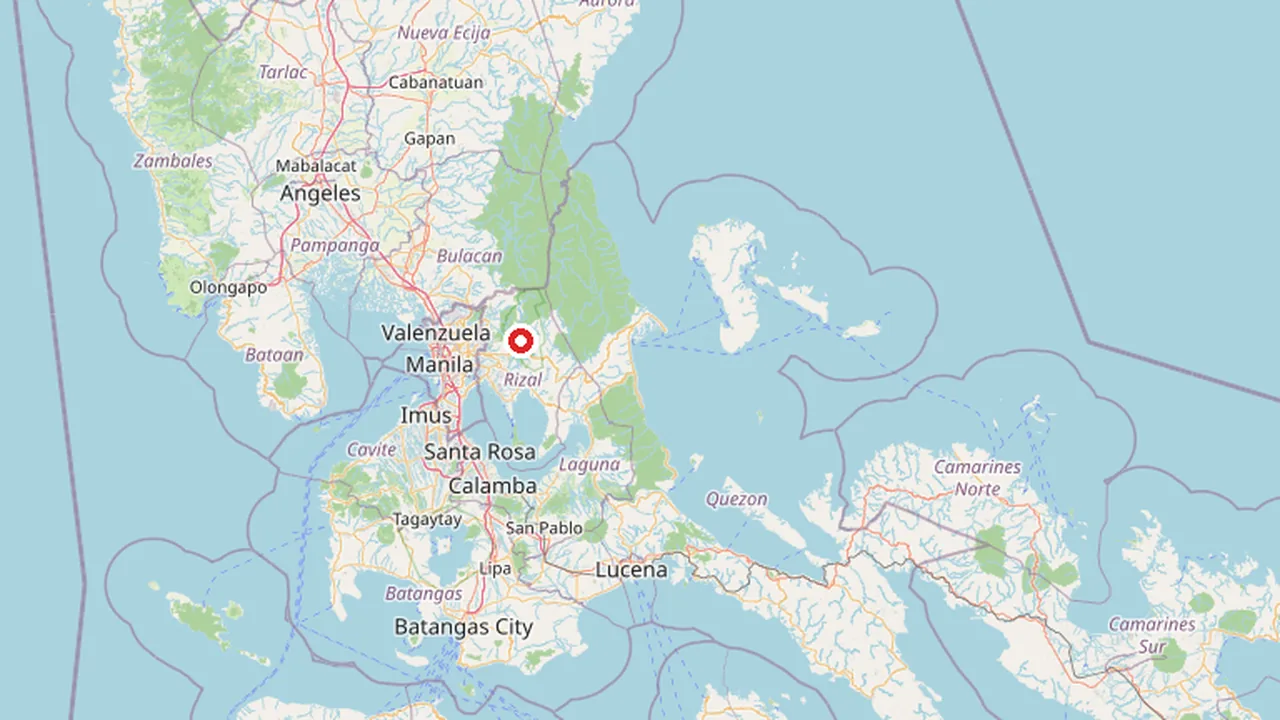
Quick reference. Rizal Province: Geographic Profile and Administrative Context has capital Q1636, area 1,192 km², population 3,416,541, founded 1901, ISO 3166-2 code PH-RIZ, led by Rebecca Ynares.
Overview
Rizal, officially designated as the Province of Rizal, is an active province situated within the Calabarzon region of Luzon, Philippines. The province is geographically positioned approximately 16 kilometers east of Manila, serving as a key eastern neighbor to the national capital region. Its administrative capital is the city of Antipolo, which functions as the primary urban center for the province. The territory is named in honor of José Rizal, widely recognized as one of the main national heroes of the Philippines, linking the region’s identity directly to the country’s historical narrative.
Rizal Province is bordered by Metro Manila to the west, Bulacan to the north, Quezon to the east, and Laguna to the southeast. The province also encompasses the northern shores of Laguna de Bay, which is the largest lake in the country. This geographical configuration places Rizal at a critical junction between the metropolitan core and the broader eastern Luzon landscape.
Geography and Topography
The province is characterized by its mountainous terrain, perched on the western slopes of the southern portion of the Sierra Madre mountain range. This topographical feature defines the physical landscape of the region, distinguishing it from the flatter plains found in other parts of Luzon. The presence of the Sierra Madre influences the local climate and land use patterns across the province.
Administrative Context
Established in 1901, Rizal Province has maintained its status as a distinct administrative unit within the regional framework of Calabarzon. The local government unit (LGU) oversees the province, with Antipolo serving as the seat of provincial administration. The province remains an active entity within the Philippine provincial system, continuing to function as a significant geographic and administrative division in eastern Luzon.
Geography and Topography
Rizal Province is characterized by its mountainous terrain, situated on the western slopes of the southern portion of the Sierra Madre mountain range. This topography defines the province’s physical landscape, distinguishing it from the flatter coastal areas of neighboring regions. The province is located in the Calabarzon region of Luzon, approximately 16 kilometers east of Manila. Its strategic position places it between the metropolitan core and the broader eastern and southern expanses of the island.
The geographic boundaries of Rizal are well-defined by its adjacent administrative divisions. To the west, the province is bordered by Metro Manila, serving as a direct eastern neighbor to the national capital region. Bulacan lies to the north, forming a boundary that separates Rizal from the northern plains of Luzon. To the east, the province shares a border with Quezon, extending along the mountainous spine of the Sierra Madre. Laguna borders Rizal to the southeast, completing the ring of neighboring provinces that surround it.
A significant feature of Rizal’s geography is its location on the northern shores of Laguna de Bay. This body of water is the largest lake in the Philippines, influencing the climate and hydrology of the southern parts of the province. The presence of the lake provides a natural boundary and a key geographical landmark for the region. The combination of mountainous elevations and lake shores creates a diverse topographical profile within the province.
| Geographic Feature | Detail |
|---|---|
| Region | Calabarzon, Luzon |
| Distance from Manila | 16 kilometers |
| Western Border | Metro Manila |
| Northern Border | Bulacan |
| Eastern Border | Quezon |
| Southeastern Border | Laguna |
| Major Water Body | Laguna de Bay (Northern Shores) |
| Mountain Range | Sierra Madre (Western Slopes) |
History and Establishment
The Province of Rizal was formally established in 1901, marking a significant administrative reorganization of the lands immediately east of Manila. This creation occurred during the early years of American colonial rule, a period characterized by the restructuring of local governance to integrate the surrounding territories into a more cohesive provincial system. The province is situated in the Calabarzon region of Luzon, serving as a critical buffer and gateway between the national capital region and the eastern provinces. Its strategic location has historically influenced its development, acting as a primary corridor for trade and military movement extending from Manila toward the Sierra Madre mountain range.
The province derives its name from José Rizal, one of the principal national heroes of the Philippines. Rizal was a multifaceted figure—a writer, ophthalmologist, and polymath—whose works, particularly Noli Me Tángere and El Filibusterismo, played a pivotal role in sparking the Philippine Revolution against Spanish colonial rule. Naming the province after him was a deliberate act to honor his contributions to the nation's identity and independence. This naming convention reflects the broader trend during the early 20th century to associate new or redefined administrative units with prominent historical figures to foster a sense of national pride and continuity.
Geographically, the province is defined by its position on the western slopes of the southern portion of the Sierra Madre mountain range. It is bordered by Metro Manila to the west, Bulacan to the north, Quezon to the east, and Laguna to the southeast. The province also encompasses the northern shores of Laguna de Bay, which is the largest lake in the country. This diverse topography, ranging from mountainous terrain to the lake's shoreline, has shaped the province's historical development and settlement patterns. The capital city of Antipolo, located within the province, serves as the administrative center and has historically been a focal point for both local governance and regional commerce. The establishment of Rizal Province in 1901 laid the foundation for its growth into a densely populated and economically significant area in the greater Manila region.
What distinguishes Rizal Province from neighboring regions?
Rizal Province occupies a singular geographic niche within the Calabarzon region, defined by its position as a transitional zone between the dense urban sprawl of Metro Manila and the rugged interior of the Sierra Madre mountain range. Located approximately 16 kilometers east of Manila, the province serves as a critical geographic buffer and ecological corridor. Its topography is distinctly mountainous, perched on the western slopes of the southern portion of the Sierra Madre, which contrasts sharply with the relatively flat plains found in many neighboring provinces. This elevation and slope create a unique microclimate and landscape that differentiates Rizal from the coastal lowlands of Laguna or the northern plains of Bulacan.
Geographic Boundaries and Regional Context
The province is bordered by Metro Manila to the west, Bulacan to the north, Quezon to the east, and Laguna to the southeast. This positioning places Rizal at the convergence of major administrative and geographic zones in Luzon. The northern shores of Laguna de Bay, the largest lake in the country, form a significant southern boundary, influencing the province’s hydrology and settlement patterns. The presence of the Sierra Madre to the east provides a natural barrier that shapes the province’s eastern topography, creating a distinct ridge-and-valley landscape that is less prominent in the more uniform terrain of adjacent areas.
Topographic Distinction
Unlike the flat agricultural plains that characterize parts of neighboring Bulacan or the coastal plains of Laguna, Rizal’s terrain is dominated by hills and mountains. This mountainous character is a defining feature, influencing everything from local climate patterns to infrastructure development. The province’s elevation and slope contribute to its reputation as a cooler, more verdant area compared to the low-lying regions surrounding it. This topographic diversity supports a variety of ecosystems and land uses, from urban development in the lower elevations to forested areas and agricultural terraces in the higher slopes. The province’s status as an active administrative unit since 1901, with Antipolo as its capital, reflects its long-standing role as a distinct geographic and political entity within the region.
Administrative Structure and Demographics
The Province of Rizal is an active administrative division within the Calabarzon region of Luzon, with its capital located in the city of Antipolo (per Philippine geographic records). The province serves as a key eastern gateway to Metro Manila, situated approximately 16 kilometers east of the national capital. Its administrative structure is defined by its position as a mountainous province on the western slopes of the southern Sierra Madre range, bordered by Metro Manila to the west, Bulacan to the north, Quezon to the east, and Laguna to the southeast. The province also encompasses the northern shores of Laguna de Bay, identified as the largest lake in the country.
Administrative Capital and Regional Role
Antipolo functions as the provincial capital and primary administrative hub for Rizal. As the seat of the local government unit (LGU), Antipolo coordinates provincial services and regional integration efforts within the Calabarzon economic zone. The province was formally established in 1901, marking its inception as a distinct administrative entity named after José Rizal, a principal national hero of the Philippines. This historical designation underscores the province’s cultural and political significance within the Luzon island group.
Demographic and Geographic Data
The following table summarizes the key administrative and geographic facts for Rizal Province, derived from authoritative sources:
| Attribute | Detail |
|---|---|
| Province | Rizal |
| Region | Calabarzon, Luzon |
| Capital City | Antipolo |
| Year Established | 1901 |
| Status | Active |
| Coordinates | 14.666666666667, 121.25 |
| Distance from Manila | 16 kilometers (9.9 mi) east |
| Borders | Metro Manila (West), Bulacan (North), Quezon (East), Laguna (Southeast) |
| Key Water Body | Laguna de Bay (Northern Shores) |
| Topography | Mountainous; Western slopes of southern Sierra Madre |
Rizal’s administrative framework supports its role as a densely populated corridor connecting the national capital to the eastern provinces. The province’s governance is structured around the LGU of Rizal, with Antipolo serving as the central node for provincial administration. No specific population figures are provided in the current grounding sources, so demographic counts are omitted to avoid numerical hallucination. The province’s geographic positioning along Laguna de Bay and within the Sierra Madre range influences its land use, infrastructure development, and regional connectivity strategies.
Significance
Rizal Province holds a distinct position in the national consciousness as one of the few administrative divisions in the Philippines named after a single national hero, Dr. José Rizal. This naming convention reflects the enduring legacy of the writer, ophthalmologist, and polymath, whose life and works significantly influenced the Philippine Revolution against Spanish colonial rule. The province serves not only as a geographical entity but also as a living tribute to the figure who is widely regarded as the country's foremost national hero. The capital city, Antipolo, anchors this provincial identity, functioning as the administrative and cultural heart of the region. The province's establishment in 1901 formalized its status within the archipelago's evolving administrative map, cementing the connection between the land and the hero it honors. This historical designation continues to shape local governance, cultural celebrations, and educational curricula throughout the region.
Geographic Buffer and Topography
Geographically, Rizal Province functions as a critical buffer zone between the dense urban sprawl of Metro Manila and the broader Luzon mainland. Located approximately 16 kilometers east of Manila, the province provides a transitional landscape that mitigates the immediate impact of metropolitan expansion. The terrain is predominantly mountainous, perched on the western slopes of the southern portion of the Sierra Madre mountain range. This rugged topography distinguishes Rizal from the flatter plains of neighboring provinces and offers a natural barrier that influences climate patterns, drainage systems, and land use. The province's position on the northern shores of Laguna de Bay, the largest lake in the country, further enhances its strategic geographic importance. This lakefront location connects Rizal to the hydrological systems of Laguna and Quezon, playing a vital role in regional water management and biodiversity conservation.
The borders of Rizal Province are defined by its immediate neighbors: Metro Manila to the west, Bulacan to the north, Quezon to the east, and Laguna to the southeast. These boundaries create a compact yet diverse landscape that supports a mix of urban, suburban, and rural communities. The proximity to Metro Manila has driven significant development, particularly in the western municipalities, which have become key residential and commercial extensions of the capital region. At the same time, the eastern and northern areas retain more of their natural character, offering recreational opportunities and ecological reserves. This duality underscores Rizal's role as both a gateway to the capital and a retreat from it, balancing economic integration with environmental preservation. The province's active status and continued growth reflect its enduring significance in the Luzon region.
How does the province's location affect its connectivity?
The geographic positioning of Rizal Province serves as a critical interface between the national capital region and the broader Luzon landmass. Located approximately 16 kilometers east of Manila, the province functions as a primary gateway for traffic flowing from Metro Manila toward the eastern and southeastern corridors of the region. This proximity to the capital has fundamentally shaped its role in the regional transport network, making it a vital transit zone rather than merely a residential or agricultural periphery. The province’s borders with Metro Manila to the west, Bulacan to the north, Quezon to the east, and Laguna to the southeast create a multi-directional connectivity hub that influences both daily commuter patterns and long-haul logistics.
Strategic Borders and Regional Integration
The western boundary with Metro Manila is the most significant driver of the province’s connectivity profile. As the immediate neighbor to the capital, Rizal absorbs a substantial volume of vehicular traffic moving eastward along major arterial roads. This border facilitates direct access to the economic center of the Philippines, allowing for rapid integration of labor and goods. The northern border with Bulacan provides a link to the Central Luzon plains, enabling north-south movement that bypasses the congested central parts of Metro Manila. Similarly, the eastern border with Quezon Province opens routes toward the Bicol region and the eastern seaboard, while the southeastern border with Laguna connects the province to the southern parts of the Calabarzon region and the industrial zones near Laguna de Bay.
Topographical Influence on Transport Routes
Rizal’s topography further defines its connectivity challenges and opportunities. The province is characterized by mountainous terrain, perched on the western slopes of the southern portion of the Sierra Madre mountain range. This elevation creates natural barriers that require engineered solutions for road and rail infrastructure. The presence of Laguna de Bay on the northern shores adds a hydrological dimension to the province’s layout, influencing the placement of bridges and causeways that link the lowland areas of Laguna and Metro Manila with the elevated districts of Rizal. The combination of mountainous slopes and lakefront geography necessitates careful planning of transport corridors, ensuring that the province remains accessible despite its varied landscape. These physical attributes reinforce Rizal’s role as a transitional zone, where the flat urban sprawl of Manila meets the rising terrain of the Sierra Madre.
Frequently asked questions
Where is Rizal Province located?
Rizal Province is situated in the Calabarzon region of the Philippines. It forms the southeastern part of Metro Manila and shares borders with several key urban and suburban areas.
What is the administrative status of Rizal?
Rizal is a first-class province within the National Capital Region's immediate vicinity. It has its own provincial government structure while maintaining close economic ties with the national capital.
How does Rizal's geography influence its development?
The province features a mix of lowland plains and mountainous terrain, particularly near the Sierra Madre range. This diverse topography supports both rapid urbanization in the north and agricultural or resort activities in the south.
Why is Rizal considered significant in the Philippine context?
Named after the national hero Dr. Jose Rizal, the province is a major economic and educational hub. Its strategic location makes it a critical commuter belt and industrial zone for Metro Manila.
What connects Rizal to neighboring regions?
Rizal benefits from extensive road networks, including the South Luzon Expressway and the Star City–Antipolo Road. These transport arteries facilitate easy access to Manila and other parts of the Calabarzon region.